Share this:
Did we just find mountain bike heaven?
No way, it's snowing! I'm standing in the garage preparing my bike and backpack for our Queyras adventure next week, while a photo from Wintersporters.nl pops up on my phone. Local Rogier is skiing a few nice powder turns on a flank under which, fifty centimeters deeper, a beautiful single track is hidden and marked on our bucket list. It is already mid-October; very early for snow, but late for real summer temperatures. Better safe than sorry, I decide to pack my winter gloves, hat and duvet jacket.
And off we go
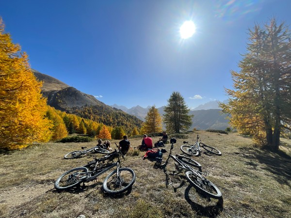
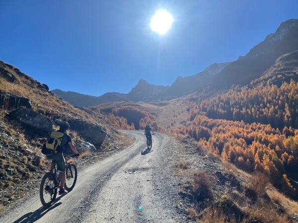
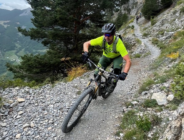
A week later we arrive in Guillestre, ready for the start of our 4-day Queyras bike adventure. Le Queyras is a protected 'Parc regional', focused on sustainability and authenticity. You will find a breathtaking landscape, with a wide variation in geology and authentic mountain villages far away from mass tourism. After a comfortable night in a local hotel, the uplift service is waiting for us after breakfast. During the half-hour ride up, we are amazed by the impressive surroundings. Huge boulders balance above the road on the right, a fast-flowing river flows deep below us on the left and high peaks tower proudly above us. We are relieved to see that the high temperatures of the past few days have largely melted the snow. A thousand vertical meters later, the asphalt turns into gravel and we know that we have arrived at the foot of our first climb. The weather is fantastic; a clear blue sky and almost summer temperatures. We pull the bikes from the trailer and click on our helmets. All five of us are packed with a 25l backpack with all the urgent items for the next four days. And off we go, on our Queyras adventure.
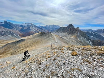
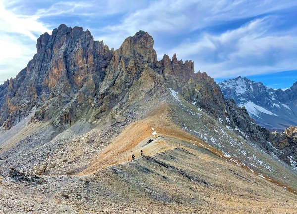
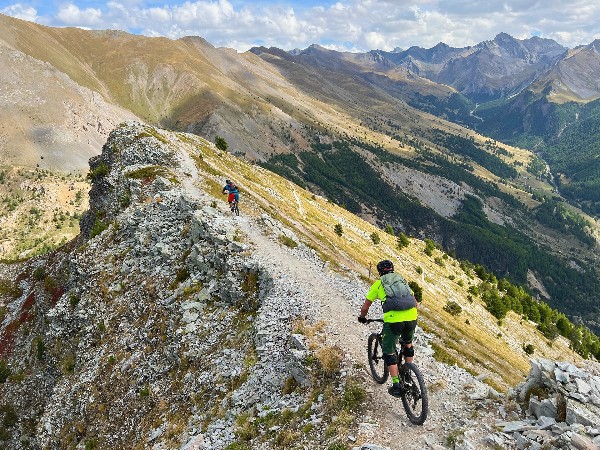
The 4x4 path quickly turns into a single track and two bends later we have both feet on the ground to push our bikes up. We paddle, push and even hike a bike our bikes up all the way to the first summit of the trip. Arriving at 2965m, we take the time for our picnic, snapthe necessary pictures and put on the knee pads for the descent. We start with a trail over a slate ridge, which also forms the border with Provence. This ridge leads us and our vision in the direction of an impressive rock formation; les Pics de la Font Sancte, which at 3385m is the highest peak of the Queyras.
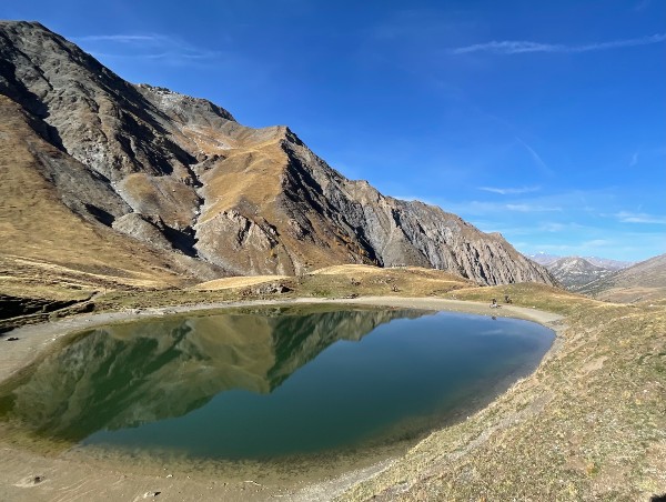
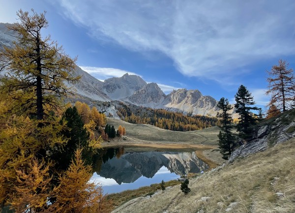
Just as the climb was largely rideable, the trail down seems to act the same. The new path may has been dug for the many hikers who walk here in the summer, but many bike parks can follow this example; what a flow does it have! A thousand meters lower we arrive at the mountain hut. The stoke is high and there is still enough time and energy to put the icing on the already delicious cake. We study the map and climb another four hundred meters until we arrive at lac Miroir; the reflecting lake. This trail is also on par with the better bike parks. We apologize to the few hikers we pass by and stoked and satisfied we arrive at the refuge for a well-deserved pint.
Putting some effort in
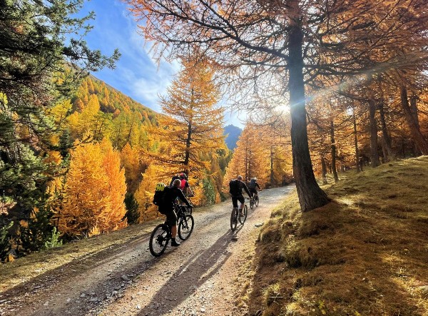
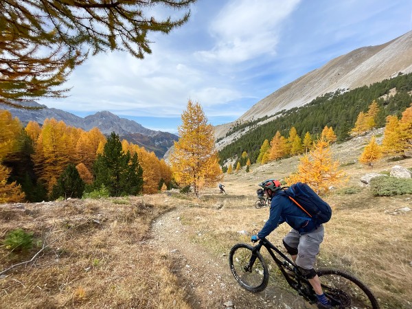
The next day starts early and chilly, but as soon as the sun rises above the mountain it quickly warms up. The climb starts with a pleasant incline and apart from a little pushing, we stay in the saddle the entire climb. On these types of point2point trips the challenge is to enjoy the climb as much as the descent and that works well here! The views are fantastic and the sunlight that 'falls' through the larche trees adds even more. From the col we can paddle further to the top, but because we have more altitude meters ahead of us later, we decide to ride around it.
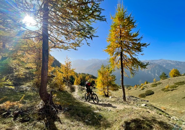
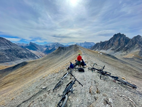
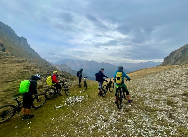
This choice works out well. A lovely balcony trail winds through the yellow-colored larches to arrive at the Col de Fromage; the cheese cowl! We honor this place by eating the cheese (and ham) sandwiches we brought with us. We did well as there is a need for extra energy. A little but sweet descent, turns quickly in an exposed balcony trail and a serious climb to reach the col. With our bikes on the shoulders we are forced to look up and soon witness a sweet looking peak above us; la Pointe de Rassis. The weather is still nice and a little IGN and Fatmap study later, we decide to give it a go.
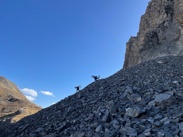
The bikes go back on the shoulders to climb a shady north face, which is so steep it must be avalanchy in the winter. It is serious mission and we arrive at the top puffing and groaning. But what a view we have from 2844m we have from here; we can see the entire Queyras, with even the Italian Monte Viso in the distance. The ridge is narrow but flowy and we ride down one after the other. Arriving at the Alpine pasture, the trail is ruined by the cows, but the larch forest that follows makes up for it. We get lost in the woods, have to do another little but sharp climb, but at the end the trail turns out to end right at our accommodation! Needless to say, the beers tasted good, the shower was welcome and the contents of the plates disappeared like snow in the southern French sun. What a day we had again!
The Italien touch
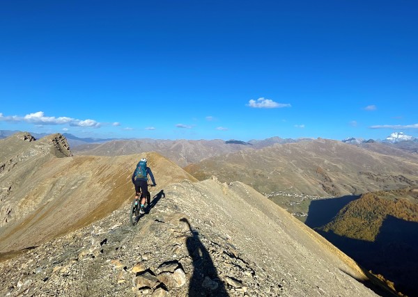
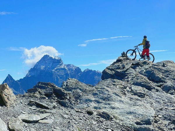
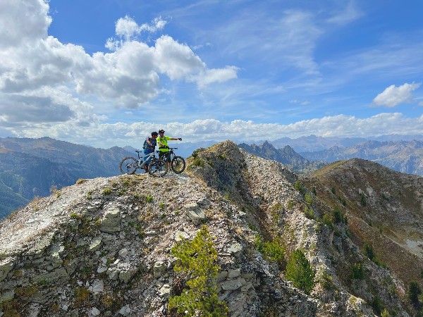
Just as the same sun rises over the Italian border the next morning, we jump on our bikes. The sky is clear blue and although we are driving at an altitude of 2000m, it is just warm for this time of year. We drive through St Veran, the highest (inhabited) village in Europe. This village has the largest ski area in the Queyras, but unlike most other French ski villages, it was not conceived on the drawing board. That's what's so cool about the Queyras; it has a lot of history and exudes authenticity. The climb is relaxed, but becomes increasingly steep. When we arrive at the pass, we see on the map that with an extra hundred meters of pushing we can reach a three-thousander. Twenty minutes later we are high-fiving at an altitude of 3025m, looking up at Monte Viso and down at the Italian Piedmont.
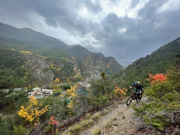
The first part of the descent turns out to be a lot more technical than we have been used to so far, with large rocks that look a bit unfriendly. This is precisely why this trail scores high again. After we cross the Route departemental to Italy, a small climb awaits, followed by a seemingly endless descent to the next valley. In summer, this trail is forbidden area for (E)mountain bikers who come here with assistance in the form of a battery or a uplift. But now the prohibition sign is gone and the trail beckons you to shred at high speed. And that's what we do; what a cool descent!
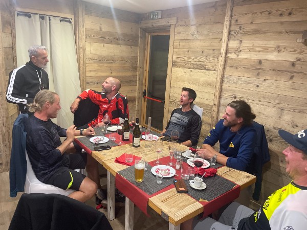
Straight sections with flow and the occasional technical section to slalom between the rocks. If the trail doesn't make you drool, the scenery will! Alpine meadows, snow-capped peaks and again a turquoise mountain lake form the backdrop to this descent. The second part of the trail requires speed and commitment to roll over and between the large rocks. The day with 1200m of climbing at an altitude above 2000m has been tough and focus is required to get down in one piece. Of course, the larches are also pleasantly present on this trail. At 1750m we reach the asphalt to continue to our next overnight stay. The Italian owners understand it well and do everything they can to make us (even more) happy. The apartment is a bit dated but spacious, the dinner was very tasty and the wines... well, they went a bit too well, let's say.
Dare to change plans
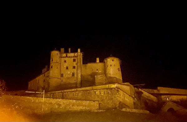
After a great Italian breakfast and even better coffee, we are ready for our last day of our 4-day Queyras exploration. The main road towards Italy was quite busy and the garage door did not appear to close completely. But under the watchful eye of the knights of Chateau Queyras, our bikes appear to have made it till the next morning. We warm up our suspension over the old village cobblestones and a little later we find our uplift, parked along the fast flowing water of the Guil river. The man introduces himself as Cyril, the boss of Guil-E bike, which is an established mountain bike name in this area. We drive north, towards Briancon. As soon as the hairpin bends to the famous Col d'Izoard appear, the landscape changes. The geology is different every day, but what we find here above the tree line is impressive; la Casse deserte. A mountain wall made up of different rocks of different hardness, resulting in a special form of erosion. Ciryl drops us just below the col at an altitude of about 2300m. With the different geology, the trail is also completely different than what we have ridden before. We race a challenging single track, straight through a ravine with loose stones. In case of heavy rain, this trail is not driveable because it turns into a raging stream. But today the weather is a dry, but some rain is on the radar.
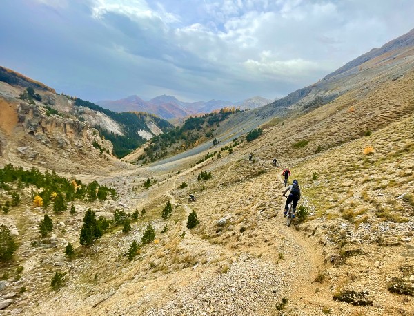
We get a picnic at the Arvieux supermarket to brave the last climb. This one turns out to be spicy; long, loose and in places and just too steep to be fun. Arriving at the Col de Furfande it is starting to rain and the wind makes it pretty chilly. Fifty meters below the col we wait in the shelter for the more let's say mindful climbers. Once we are complete, we quickly descend via a flowy trail in search of a sheltered spot for our lunch. My mountain mantra is, make plans, but dare to adapt, in other words; It is a good idea to forge a plan (together), but dare to change and adjust this plan if circumstances require it. It is now day four, we have climbed a lot and ridden beautiful trails, but we are getting tired and had a bit too much fun yesterday eve. Also the rain makes it cold and the trails pretty slippery. We therefore decide to abandon plan A, which would have started with a steep climb and then descend via a technical and challenging trail. We go for plan B; descend directly via a trail that looks a bit easier on the map. It's a gamble, because we know that plan A is a high-scoring trail, while plan B concerns a hiking trail that we impulsively found on the IGN map. And yes, you felt it coming; what a drama this last trail is! A 4x4 path with stones, impassable sections, fallen trees...
haha, just kidding; we are in the Queyras right?! Where so far every trail we have ridden has scored at least an 8 and many trails have even rated a big 9. This also applies to this descent; some of it even turned out to have been shaped a bit by the locals, with some berms and jumps and the usual Queyras flow! What a icing on the already tasty cake with whipped cream.
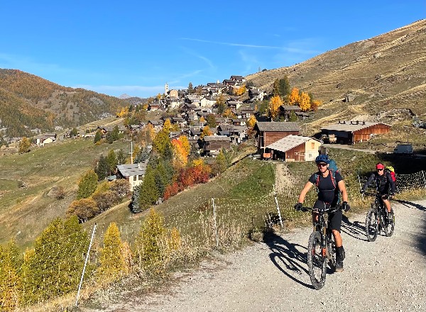
Back on the main road we have a deja vu; this is the road we uplifted on our first day. After a few kilometers we find one last option to avoid the asphalt on our beloved IGN map. We ride a nice single track to the bridge over the Guil, passing under the Mont Dauphin fortress, to arrive at our starting point. What a great bike adventure it has been. It feels like we have found mountain bike heaven here in the Queyras. In silence but with ear to ear smiles we are enjoying a last well deserved beer in the local pub.
Breefly
We rode a point2point trip through the Queyras in 4 days with a group of 6 riders. Apart from the 2 uplifts that we used, we climbed everything using good old leg power. We climbed and descended about 1200-1500 meters per day, in the search for the best singletracks. The trails seem made for mountain bikes; lots of flow and often staying at altitude for a long time, meandering through the fantastic larch forests that slightly turned yellow before loosing their needles. The Queyras is a regional park, located south of Briancon and bordering Provence to the south and Italy to the east. In each of the 8 villages of the Queyras you will find accommodation, often called a gite. Be aware that most gites close their doors in October. In the summer the trails get (to) busy with walkers, but in the automn you'll have the area for yourselves. We were lucky with the Indian Summer, as the the mountains might turn white already mid October!
If you are curious about all the beauty that the Queyras has to offer, you can join us on another Queyras Bike Adventure from October 12-19. A 6-day point2point mountain bike adventure, in search of the best single tracks of this unique mountain massif.